Posts Tagged ‘maps’
“When I was a kid my parents moved a lot, but I always found them”*…

Pangea was the latest in a line of supercontinents in Earth’s history.
Pangea began developing over 300 million years ago, eventually making up one-third of the earth’s surface. The remainder of the planet was an enormous ocean known as Panthalassa.
As time goes by, scientists are beginning to piece together more information on the climate and patterns of life on the supercontinent. Similar to parts of Central Asia today, the center of the landmass is thought to have been arid and inhospitable, with temperatures reaching 113ºF (45ºC). The extreme temperatures revealed by climate simulations are supported by the fact that very few fossils are found in the modern day regions that once existed in the middle of Pangea. The strong contrast between the Pangea supercontinent and Panthalassa is believed to have triggered intense cross-equatorial monsoons.
By this unique point in history, plants and animals had spread across the landmass, and animals (such as dinosaurs) were able to wander freely across the entire expanse of Pangea…
Since the average continent is only moving about 1 foot (0.3m) every decade, it’s unlikely you’ll ever be alive to see an epic geographical revision to the world map.
However, for whatever life exists on Earth roughly 300 million years in the future, they may have front row seats in seeing the emergence of a new supercontinent: Pangea Proxima…
More– including how it happened and a larger version of the image above– at “Incredible Map of Pangea With Modern-Day Borders.”
* Rodney Dangerfield
###
As we go with the flow, we might send historic birthday greetings to Dorothy Annie Elizabeth Garrod; she was born on this date in 1892. An archaeologist who specialized in the Palaeolithic period, she was the first women to hold a chair at an Oxbridge university, serving as of Disney Professor of Archaeology at the University of Cambridge from 1939 to 1952.

“Agriculture changes the landscape more than anything else we do”*…
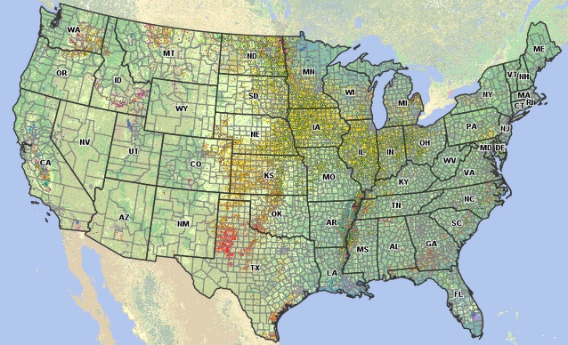
From the USDA, a (zoomable) map of which crops are grown where in the U.S.: “Cropscape.”
* Michael Pollan
###
As we contemplate cultivation, we might note that today is National Animal Crackers Day. Small crackers/cookies baked in the shape of animals, they were imported from England to the U.S. in the second half of the 19th century. then produced domestically by a number of bakers starting in the 1870s.
But by the turn of the century, several of those bakeries had merged to become the National Biscuit Company, which began to produce a branded version, “Barnum’s Animals,” featuring animals from the Barnum and Bailey Circus. While earlier animal cracker were sold to merchants in bulk (to be sold to customers from barrels), Nabisco’s were packaged in a colorful, circus-themed box with a string that allowed it to be hung from a Christmas tree. Initially retailing for 5 cents a package, they were– and remain– a huge hit.

Some of “Barnum’s Animals”
“It is necessary to keep one’s compass in one’s eyes”*…

A “compass rose” is a graphic device found on maps and nautical charts (as well as on the faces of compasses and some monuments) that displays the orientation of the cardinal directions (north, east, south, and west) and their intermediate points.

And as these examples from the collection of the The American Geographical Society Library demonstrate, they can also be fascinating– and beautiful– graphic elements in their own right.
See more at the AGSL’s Compass Rose Flickr page. Browse the Library’s full digital collection here.
* Michelangelo
###
As we find our way, we might spare a pining thought for Petrarch (Francesco Petrarca); it was on this date in 1327, after he’d given up his vocation as a priest, that he first set eyes on “Laura” in the church of Sainte-Claire d’Avignon– an encounter that awoke in him a passion that spawned the 366 poems in Il Canzoniere (“Song Book”).
Considered by many to have been “the Father of Humanism,” and reputed to have coined the term “Renaissance,” Petrarch was most famous in his time for his paeans to his idealized lover (who was, many scholars believe, Laura de Noves, the wife of Hugues de Sade). But Petrarch’s more fundamental and lasting contribution to culture came via Pietro Bembo who created the model for the modern Italian language in the 16th century largely based on the works of Petrarch (and to a lesser degree, those of Dante and Boccaccio).
Laura de Noves died on this date in 1348.

Lura de Noves

Petrarch
“A map is the greatest of all epic poems”*…

A marmot hiding in plain sight in the Swiss Alps
Errors—both accidental and deliberate—are not uncommon in maps (17th-century California as an island, the omission of Seattle in a 1960s AAA map). Military censors have long transformed nuclear bunkers into nondescript warehouses and routinely pixelate satellite images of sensitive sites. Many maps also contain intentional errors to trap would-be copyright violators. The work of recording reality is particularly vulnerable to plagiarism: if a cartographer is suspected of copying another’s work, he can simply claim to be duplicating the real world— ideally, the two should be the same. Mapmakers often rely on fictitious streets, typically no longer than a block, to differentiate their accounts of the truth (Oxygen Street in Edinburgh, for example).
But there is another, less institutional reason to hide something in a map. According to Lorenz Hurni, professor of cartography at ETH Zurich, these illustrations are part inside joke, part coping mechanism. Cartographers are “quite meticulous, really high-precision people,” he says. Their entire professional life is spent at the magnification level of a postage stamp. To sustain this kind of concentration, Hurni suspects that they eventually “look for something to break out of their daily routine.” The satisfaction of these illustrations comes from their transgressive nature— the labor and secrecy required to conceal one of these visual puns…
Slipping one past one of the most rigorous map-making institutions in the world: “For Decades, Cartographers Have Been Hiding Covert Illustrations Inside of Switzerland’s Official Maps.”
* Gilbert H. Grosvenor (President of the National Geographic Society, first editor of the magazine, and champion of cartography [and photojournalism])
###
As we hide Easter eggs, we might recall that it was on this date in 1345– according to 14th century scholars at the University of Paris– the Black Death was created… from what they called “a triple conjunction of Saturn, Jupiter and Mars in the 40th degree of Aquarius, occurring on the 20th of March, 1345.”
AKA the Pestilence, the Great Bubonic Plague, the Great Plague, the Plague, or less commonly the Great Mortality or Black Plague, the Black Death was actually transmitted by fleas who had fed on diseased rats. It killed an estimated 75 to 200 million people in Eurasia, peaking in Europe from 1347 to 1351.
More on “the greatest catastrophe ever.”

Spread of the Black Death in Europe and the Near East (1346–1353)
“Now my eyes are turned from the South to the North”*…
Your correspondent is off for a week or so to time zones sufficiently distant that regular service will be suspended for about a week. (R)D should return on or around March 15. Meantime…

One of the selections at “Hilarious Terrible Maps.”
[TotH to KE]
###
As we find our way, we might recall that it was on this date in 1930 that General Foods put the first nationally-branded individually-packaged frozen foods– “Birds Eye Frosted Foods”– on sale in 18 retail stores in Springfield, Mass. to test the market. General Foods (recently renamed from the Postum Corporation) had acquired the frozen food business from Clarence Birdseye; inspired by seeing Canadians thawing and eating naturally frozen fish, Birdseye had invented the category in the early 1920s. The initial Birds Eye line featured 26 items, including 18 cuts of frozen meat, spinach and peas, a variety of fruits and berries, blue point oysters, and fish fillets.

Clarence Birdseye and his handiwork
You must be logged in to post a comment.