Posts Tagged ‘supercontinent’
“Everything is in motion. Everything flows.”*…
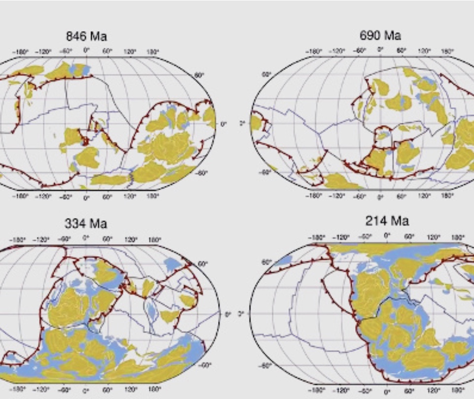
(Roughly) Daily has looked at the related theories of plate tectonics and continental drift before (e.g., here and here). They are relatively young: proposed in the early twentieth century by Alfred Wegener, they weren’t widely accepted until 1960 or so. Now they’re fundamental– and allowing scientists to reconstruct the earth’s past. To wit, this animation looking at the Earth’s tectonic plate movement from 1 ga (geological time for 1 billion years ago) to the present-day (the video starts at time 1,000 ma [1,000 million years ago], and moves at the rate of about 25 million years every second)…
Here’s a even more ambitious project, looking back 3.3 billion years:
More on plate tectonics and the supercontinents that it formed (and unformed) at Visual Capitalist.
* William Hazlitt
###
As we buckle up, we might recall that in the very late 50s, the Ohio Art Company– which had been pursuing a pair of business: toys (e.g., windmills and a climbing monkey) and custom metal lithography products for food container and specialty premium markets– found a way to merge the two. It acquired the rights to French electrician André Cassagnes‘ L’Écran Magique (The Magic Screen)– a drawing toy that allowed users to spin knobs to create line drawings, which could be erased by by turning the device upside down and shaking it. Ohio Art renamed it the Etch A Sketch, and introduced it in this date in 1960.
At its launch, which was near the peak of the Baby Boom, the Etch A Sketch was priced at $2.99 (equivalent to $26 in 2020); the company sold 600,000 units that year … and went on to sell over 100 million units and to earn a place in the National Toy Hall of Fame.

“The forces which displace continents are the same as those which produce great fold-mountain ranges”*…

Some 240 million years ago, the patch of land that would one day become the National Mall was part of an enormous supercontinent known as Pangea. Encompassing nearly all of Earth’s extant land mass, Pangea bore little resemblance to our contemporary planet. Thanks to a recently released interactive map, however, interested parties can now superimpose the political boundaries of today onto the geographic formations of yesteryear—at least dating back to 750 million years ago.
The results are intriguing: During the Early Triassic Epoch, the National Mall in Washington, D.C., for example, was wedged almost directly adjacent to Mauritania, yet to be separated from the Northwest African country by the vast waters of the Atlantic Ocean.
Ancient Earth, the tool behind this millennia-spanning visualization, is the brainchild of Ian Webster, curator of the world’s largest digital dinosaur database [an old friend of (Roughly) Daily]…
Visualize the changes between the Cryogenian Period and the present: “This Map Lets You Plug in Your Address to See How It’s Changed Over the Past 750 Million Years.”
* Alfred Wegener, the originator of theory of continental drift
###
As we go with the flow, we might send rocky birthday greeting to Maurice-Irénée-Marie Gignoux; he was born on this date in 1881. A geologist, he helped chart the stratigraphy of the Mediterranean during the Pliocene Epoch (5.3 to 2.6 million years ago) and the Quaternary Period (from 2.6 million years ago to the present). His work with “fold models” (that allowed playing out the tectonic forces at work in continental drift and in the formation of mountains) led to a deeper understanding of the structure of the Alps.

“When I was a kid my parents moved a lot, but I always found them”*…

Pangea was the latest in a line of supercontinents in Earth’s history.
Pangea began developing over 300 million years ago, eventually making up one-third of the earth’s surface. The remainder of the planet was an enormous ocean known as Panthalassa.
As time goes by, scientists are beginning to piece together more information on the climate and patterns of life on the supercontinent. Similar to parts of Central Asia today, the center of the landmass is thought to have been arid and inhospitable, with temperatures reaching 113ºF (45ºC). The extreme temperatures revealed by climate simulations are supported by the fact that very few fossils are found in the modern day regions that once existed in the middle of Pangea. The strong contrast between the Pangea supercontinent and Panthalassa is believed to have triggered intense cross-equatorial monsoons.
By this unique point in history, plants and animals had spread across the landmass, and animals (such as dinosaurs) were able to wander freely across the entire expanse of Pangea…
Since the average continent is only moving about 1 foot (0.3m) every decade, it’s unlikely you’ll ever be alive to see an epic geographical revision to the world map.
However, for whatever life exists on Earth roughly 300 million years in the future, they may have front row seats in seeing the emergence of a new supercontinent: Pangea Proxima…
More– including how it happened and a larger version of the image above– at “Incredible Map of Pangea With Modern-Day Borders.”
* Rodney Dangerfield
###
As we go with the flow, we might send historic birthday greetings to Dorothy Annie Elizabeth Garrod; she was born on this date in 1892. An archaeologist who specialized in the Palaeolithic period, she was the first women to hold a chair at an Oxbridge university, serving as of Disney Professor of Archaeology at the University of Cambridge from 1939 to 1952.

You must be logged in to post a comment.