Posts Tagged ‘geography’
“Education is the key to unlock a golden door of freedom”*…

Historian (and author) Ada Palmer on what she convincingly argues is an unappreciated aspect of American cultural and political history…
Many shocking, new ideas shaped the American Experiment and related 18th century democratic ventures; as an historian of the period, I often notice that one of the most fundamental of them, and most shocking to a world which had so long assumed the opposite, often goes unmentioned — indeed sometimes denied — in today’s discussions of democracy: the belief that all people are educable. I think it’s urgent that we bring that principle back into the spotlight if we want to defend democracy from one of its common failure modes: pseudo-populist oligarchy.
Within “all men are created equal” lies the sub-principle that all people, or specifically all enfranchised citizens of a state (which often at the time meant white male adults, though some made it broader, or narrower) that all such people are, if given appropriate educational resources, capable of learning, exercising sound judgment, and acting on said judgment, thus that they all people are equally rational and capable of competent self-governance. This thesis does not assume that all people when adults are equally prepared to participate in government, but that all people when born have the capacity to absorb education if given access to it. Rare intellectual disabilities might make the education process challenging for certain individuals, but (the thesis argues) even then the right support and resources make education possible, and such situations are not the default human state. This is the thesis that all people are fundamentally educable.
Many in the 18th c. who thought democracy was absurd rejected it because they disagreed with this thesis, believing that the majority of people (even of white men) were not educable, i.e. that even with educational resources most people were born incapable of being guided by Reason and making sound political judgments. Those who believed this predicted that government by the people would collapse into absurdity, since it would be led by a parliament of fools…
[Palmer runs through pre-modern and Enlightenment thinking on the subject– most of which dismissed democracy as impractical on grounds that went to the incapacity of the many to understand and make intelligent decisions…]
It took a lot to get even a small radical fringe by 1750 to entertain the notion that all people–or even just all men–were created equally educable. A long survey of the causes would get unwieldy, but they include (among other things) contact with indigenous cultures in the Americas and other regions which had functional governments without European-style systems, revolutions in medicine and the understanding of the sense organs which undermined old hierarchy-enforcing ideas about how cognition and sensation functioned, second-order consequences of the rags-to-riches path opened by Renaissance courts employing scholars from any background so long as they had good Latin, and Protestantism’s second-order implication that, if people didn’t need priests as intermediaries between their prayers and God, perhaps they didn’t need aristocrats as intermediaries between them and power. But by 1750 that fringe existed, and had enough momentum to implement its experiment in the new United States, which most people who were considered sensible at the time thought would quickly degenerate into chaos, because they didn’t think most people were capable of understanding the world enough to vote sensibly, draft legislation, or serve in a congress, and that the tiny wise minority would be drowned out by the majority wanting to vote for dining on the king’s tab and killing all the lawyers…
Democracy can function, says Thomas Paine (to pick a spokesman for the US founders), because human beings are fundamentally educable, and if given a good teacher, a good reading list, and some newspapers, all human beings, or at least the overwhelming majority of them, will become capable of wise judgment and self-rule. One’s civic duty is not to identify the wise minority and put them in power, but to disseminate the tools of education so the majority can become wise. This thesis is opposed to aristocracy, to oligarchy, to timocracy, even to most forms of meritocracy, since education isn’t supposed to prepare people to be sorted out by the exam but to demonstrate that human beings are so excellent that everyone can pass it…
… Today’s America has seen decades of the intentional conservative-led starving and squeezing of public education, efforts to increase the disparity in education quality between public education and private or charter school education, conservative-led homeschool movements which aim to expose people to a narrow range of ideology, and also the devastation of newspapers, journalism, and a vast misinformation campaign. All this adds up to preventing many who are educable from becoming educated. Thomas Paine, and those I’m using him to represent, would recognize this as a sabotage of their system, one they would say might indeed enable Cade-style populism, which (as in Henry VI) is easy for ambitious elites to then harness to their own ends. Thus, Paine would say: of course the democracy isn’t working well if such an essential precondition is being sabotaged.
In sum, we need to talk more about the vital tie between democracy and the conviction that all people are created educable. It helps make clear how strategic the strangulation of educational resources is, and that one of the less loud but most dangerous threats to our confidence in democracy is the project to make it seem like most people can’t make sensible political judgments, reducing people’s confidence in democracy as a system by seeming to prove true conservative principle that there will always be a few who should rule and many who can’t. When I see conservative thinking start to show up in acquaintances (or Silicon Valley leaders) who consider themselves progressive but also consider themselves smart, it often begins with them feeling that most people are stupid and the world would be better off if the smart were in charge. One can often get such people to pause and reflect by bringing up the question of whether they think all people are fundamentally educable, and whether the solution isn’t to put the reins of power into genius hands but to put the Encyclopedia in everyone else’s. Information is key. Those peasants who shared commons maintained them sustainably for centuries because (as we now recognize) they were educated in the ways that mattered, they learned from families and communities to understand what they were doing, using local knowledge of commons, grazing etc. as they made choices. If one’s democratic state is the commons, people will likewise maintain it well, but not if they’re intentionally deprived of access to basic knowledge of how it works and what can harm or heal it, and drowned instead in deliberate falsehoods.
We all know we need to support education & good journalism, and combat misinformation, but revisiting the principle that all people are created educable is a good way to remember that these are not merely invaluable social goods, like sanitation or public parks. They were conceived from the start as essential components of modern democracy, in direct opposition to the many-centuries-old conservative principle that some are best to rule and others to be ruled. Enlightenment-style democracy cannot function without the conviction that all people are created educable. If we forget that, if we doubt it, if we let it shake our confidence in the experiment which didn’t turn into Jack Cade for more than two centuries (bets were not on America surviving for so long in 1776!), we risk opening the gates to the old failure mode of oligarchy rising when democracy wavers…
In support of the engine of the American Experiment: “All People Are Created Educable, a Vital Oft-Forgotten Tenet of Modern Democracy,” from @Ada_Palmer.
* George Washington Carver
###
As we enable education, we might recall that it was on this date in 1818 (15 years after the Senate ratified the Louisiana Purchase) that the “Convention respecting fisheries, boundary and the restoration of slaves” (also known as the London Convention, Anglo-American Convention of 1818, Convention of 1818, or most widely and most simply as the Treaty of 1818) was signed by The U.S. and the United Kingdom.
Primarily aimed at settling border disputes, the treaty set the Canada–United States border on the 49th parallel for most of its length. The British ceded all of Rupert’s Land south of the 49th parallel and east of the Continental Divide, including all of the Red River Colony south of that latitude, while the United States ceded the northernmost edge of the Missouri Territory north of the 49th parallel.
The treaty also allowed for joint occupation and settlement of the Oregon Country, known to the British and in Canadian history as the Columbia District of the Hudson’s Bay Company, and including the southern portion of its sister district New Caledonia.

“Dust to dust”*…
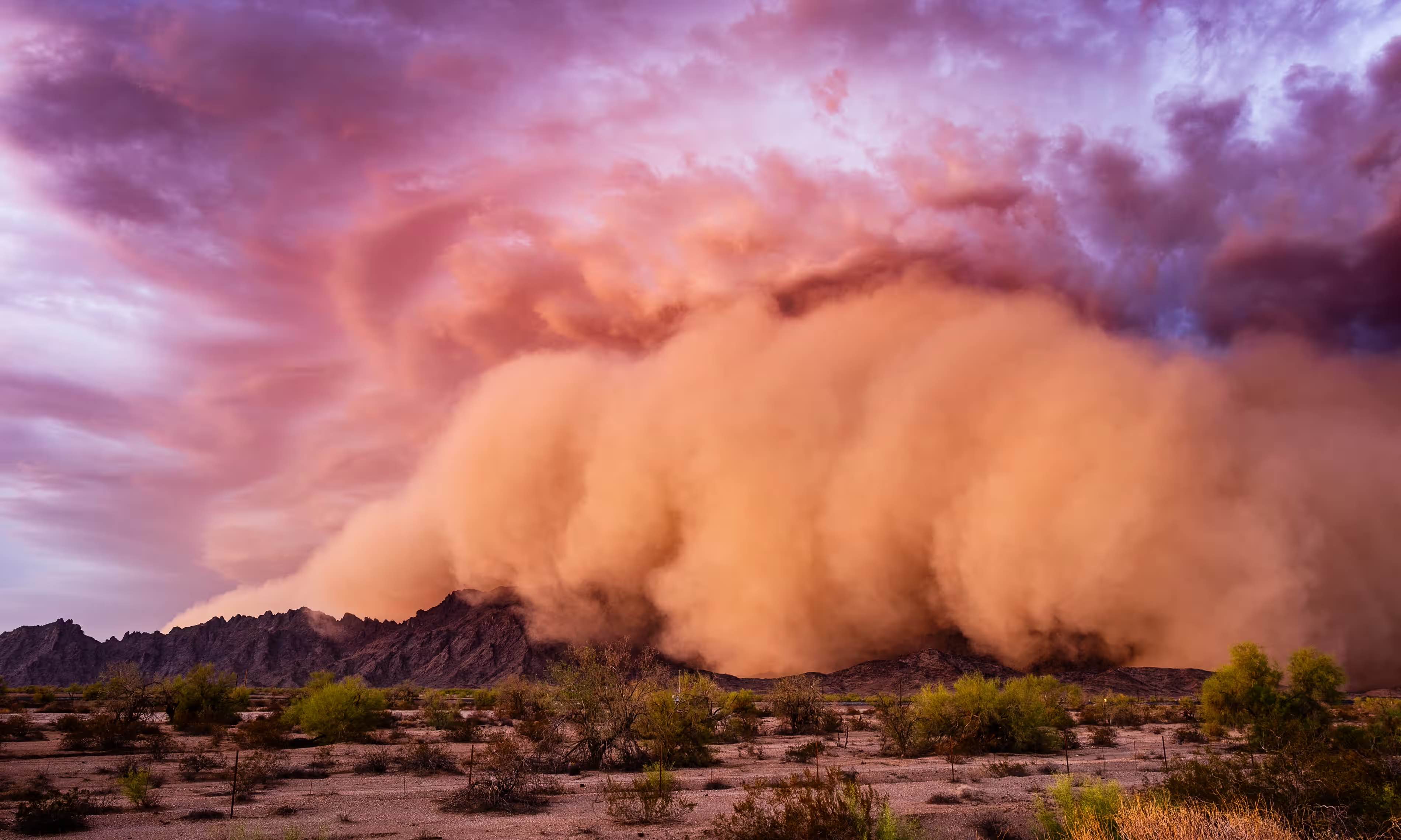
Back in 2016, we visited Jay Owens and his fascinating newsletter on dust… which went silent a couple of years later. Those of us who missed it, and were worried about its author were relieved to learn that he’d pulled back in order to turn his thinking into a book. That book is now here: Dust: The Modern World in a Trillion Particles, and The Guardian is here with an excerpt…
… Nobody normally thinks about dust, what it might be doing or where it should go: it is so tiny, so totally, absolutely, mundane, that it slips beneath the limits of vision. But if we pay attention, we can see the world within it.
Before we go any further, I should define my terms. What do I mean by dust? I want to say everything: almost everything can become dust, given time. The orange haze in the sky over Europe in the spring, the pale fur that accumulates on my writing desk and the black grime I wipe from my face in the evening after a day traversing the city. Dust gains its identity not from a singular material origin, but instead through its form (tiny solid particles), its mode of transport (airborne) and, perhaps, a certain loss of context, an inherent formlessness. If we knew precisely what it was made of, we might not call it dust, but instead dander or cement or pollen. “Tiny flying particles,” though, might suffice as a practical starting definition…
…
Dust is simultaneously a symbol of time, decay and death – and also the residue of life. Its meaning is never black or white, but grey and somewhat fuzzy. Living with dust – as we must – is a slow lesson in embracing contradiction: to clean, but not identify with cleanliness; to respect the material need for hygiene while distrusting it profoundly as a social metaphor…
A fascinating sample of a fascinating book: “Empire of dust: what the tiniest specks reveal about the world,” from @hautepop in @guardian.
Pair with: “Nothing is built on stone; all is built on sand” and “In every grain of sand there is the story of the earth.”
* from the burial service in the Book of Common Prayer
###
As we examine the elemental, we might send exploratory birthday greetings to Friedrich Wilhelm Heinrich Alexander von Humboldt; he was born on this date in 1769. The younger brother of the Prussian minister, philosopher, and linguist Wilhelm von Humboldt, Alexander was a geographer, geologist, archaeologist, naturalist, explorer, and champion of Romantic philosophy. Among many other contributions to human knowledge, his quantitative work on botanical geography laid the foundation for the field of biogeography; he surveyed and collected geological, zoological, botanical, and ethnographic specimens, including over 60,000 rare or new tropical plants.
As a geologist, Humboldt made pioneering observations of geological stratigraphy, structure (he named the Jurassic System), and geomorphology; and he understood the connections between volcanism and earthquakes. His advocacy of long-term systematic geophysical measurement laid the foundation for modern geomagnetic and meteorological monitoring.
For more, see: The Invention of Nature: Alexander Von Humboldt’s New World.

“The map? I will first make it.”*…

For map enthusiasts of all ages– Very Expensive Maps. As its self-description explains…
You get what you pay for: Very Expensive Maps is a podcast by cartographer Evan Applegate in which he interviews better cartographers. Listen to the best living mapmakers describe how they create worlds in ink, pixels, graphite, threads, paint, ceramic, wood and metal.
A podcast about maps? Let Jason Kottke reassure you…
A podcast about a visual medium like maps is maybe a tiny bit like dancing about architecture, but Applegate makes it work. The archives [from which, the examples above] are a key part of the show… lots of links to the maps discussed during each episode…
Applegate’s hope that you will be inspired: “Remember: you can, and should, make your own maps.“
* Patrick White, Voss
###
As we contemplate cartography, we might recall that it was on this date in 1682 that William Penn receives the area that is now the state of Delaware (from James, the Duke of York, who gotten it from the defeated previous owners, the Dutch), and added it to his colony of Pennsylvania. New maps were created.

“Geography is destiny”*…
Why are some large regions (like China) politically unified, while others (like Europe) are divergent? Researchers at The Centre for Economic Policy Research have tested a leading theory…
Why are some parts of the world politically fragmented while others tend to be dominated by a single state? This age-old question has implications for many important topics in comparative economic development such as the origins of the Great Divergence (see Broadberry 2021) or the divergence in political institutions between China and Europe (see Jia et al. 2021).
Scholars going back at least as far as Montesquieu and Hume have attributed the rise of Western Europe to its persistent political fragmentation. More recently, Jones (2003), Mokyr (2016, 2017), and Scheidel (2019) have developed this thesis in novel ways. These authors acknowledge that a polycentric state system has static costs such as tariff barriers and more wars but argue that, on the net, it is associated with better dynamic incentives for intellectual innovation and state building.
But what determines these patterns of fragmentation? More concretely: what factors account for the prevalence of political polycentrism in Europe and the prominence of political centralisation in China? A leading explanation of this phenomenon is the ‘fractured land’ hypothesis, most famously stated by Diamond (1997). According to this view, fractured land such as mountain barriers, indented coastlines, and rugged terrain precluded the development of large empires in Europe. In comparison, China’s geographical features led to its recurring unifications.
While the fractured land hypothesis has been widely cited and much criticised (e.g. Hoffman 2015), it has not been formally modeled or tested. In Fernández-Villaverde et al. (2022), we fill this gap by providing a quantitative investigation of the fractured-land hypothesis. We do so by modeling the dynamic process of state-building and exploring how fractured land shaped inter-state competition in unexpected, non-linear ways…
Simulating the model between 1000 BCE and 1500 CE, it can replicate the fragmentation of Europe and the consolidation of China. Modified versions of the model can predict patterns of development in the Americas and Africa, while future extensions could try to disentangle the importance of culture and religion versus geography…
Fascinating: “The fractured land hypothesis: Why China is Unified but Europe is not,” from @cepr_org.
* Abraham Verghese
###
As we muse on the model (and remember that “fragmentation” is relative), we might recall that it was on this date in 1863, in the midst of the Civil War, that West Virginia was admitted as a state to the Union.
A key border state during Civil War, it was the only state to form by separating from a Confederate state (Virginia), one of two states (along with Nevada) admitted to the Union during the Civil War, and the second state to separate from another state, after Maine separated from Massachusetts in 1820.
Some of its residents held slaves, but most were yeoman farmers, and architects of statehood provided for the gradual abolition of slavery in the new state constitution. Indeed, the state legislature abolished slavery in the state, and at the same time ratified the 13th Amendment abolishing slavery nationally on February 3, 1865.

“When you leave the Island of Pentam and sail about 100 miles, you reach the Island of Java”*…
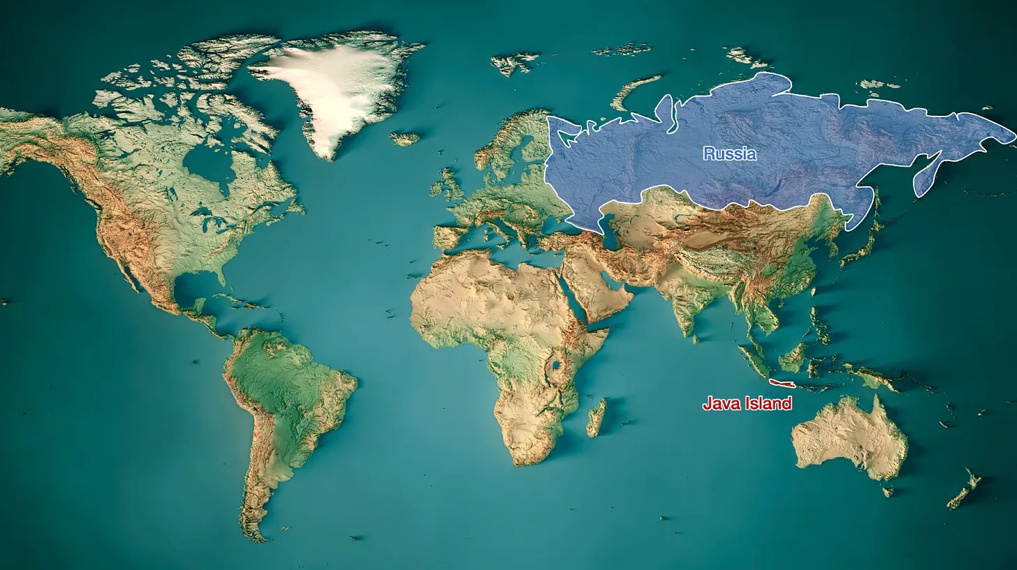
Indonesia is the 14th largest country by area at 735,358 square miles; Java, the island on which the capital Jakarta is located, is only 58,000 square miles– but Java is home to over half the Indonesian population, over 150 million people. It’s the most populous island in the world, and one of its most populous places. Tomas Pueyo explores the reasons why…
Java’s population density is 1,100 people per square km. This is 3x the density of Japan or the Philippines, 7x that of China, 30x that of the US. It’s nearly the density of Houston, Texas. For an entire island! With volcanoes!
Even weirder: Its neighboring islands in Indonesia are not that densely populated. Compared to its big neighboring islands, it’s 8x more densely populated than Sumatra and 30x more than Borneo.
Why!? What made this island so special?
Read on for a fascinating explanation: “Why is Java So Weird?!” from @tomaspueyo via his wonderful newsletter Uncharted Territories.
* Marco Polo (who was probably, it turns out, actually talking about Sumatra)
###
As we dig into development, we might recall that it was on this date in 1497 that Dominican friar and populist agitator Girolamo Savonarola, having convinced the populace of Florence to expel the Medici and recruited the city-state’s youth in a puritanical campaign, presided over “The Bonfire of the Vanities,” the public burning of art works, books, cosmetics, and other items deemed to be vessels of personal aggrandizement. Many art historians, relying on Vasari’s account, believe that Botticelli, a partisan of Savonarola, consigned several of his paintings to the flames and “fell into very great distress.” Others are not so certain. In any case, it seems sure that the fire consumed works by Fra Bartolomeo, Lorenzo di Credi, and many other painters, along with a number of statues and other antiquities.

You must be logged in to post a comment.