Posts Tagged ‘geography’
“I want to make a long journey”*…
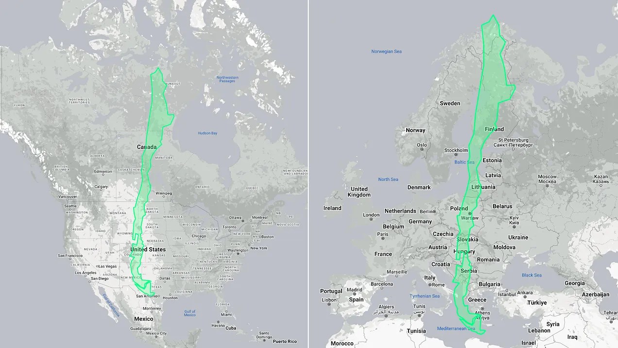
Thomas Pueyo on how geography shaped the longest (and proportionately thinnest) country in the world…
Chile is as long as the [vertical dimensions of]US and Canada combined.
Chile is as long as all of Europe!Chile is so long, it’s curved.

How long is it?
Why not longer?
Why is no other country as thin?
How does that make Chileans incomprehensible?
These questions (and more) answered: “Why Is Chile So Long?” from @tomaspueyo
* (Chilean poet) Pablo Neruda
###
As we stretch, we might recall that it was on this date in 1730 that the Valparaíso earthquake occurred. (As Pueyo explains, Chile’s unique geography and geology have frequently seismic implications.)
The quake had an estimated magnitude of 9.1–9.3 and triggered a major tsunami with an estimated magnitude of Mt 8.75, that inundated the lower parts of Valparaíso and caused severe damage from La Serena to Chillan; the tsunami affected more than 620 mi of Chile’s coastline.
While damage was widespread, only a few deaths were recorded due to the earthquake, reportedly because a strong foreshock had prompted people to leave their homes. Similarly, the subsequent tsunami: inhabitants ran to higher ground after seeing the water recede, so that only a few were killed.

“Nature is the source of all true knowledge”*…

Jonathan Keats on why– and how– clocks that use nature to measure time can reintegrate people into the environment and counteract the calamities of the Anthropocene…
In his studio on the east coast of Vancouver Island, the master clockmaker Phil Abernethy is crafting a timepiece that will be calibrated in a manner that no horologist has ever attempted. It won’t show the minutes and hours of an ordinary human day. Instead, his clock will display time as experienced by some of the oldest trees on the planet.
Using techniques he’s honed over a lifetime, Abernethy will machine the gears by hand in traditional materials such as steel and brass. But the pendulum will respond to the forest: When trees grow quickly, the hours will advance more rapidly; more lethargic growth will result in a slower tempo. Over centuries, the long-term fate of the canopy will be registered on a calendar that may deviate from the Gregorian date by decades or more.
Abernethy has been commissioned to fabricate the arboreal clock by the Nevada Museum of Art. Standing 12 feet tall, the clock will be the first physical manifestation of an environmental timekeeping project I have been developing over the past decade. Some of the clocks in the project respond to rivers; Abernethy’s enlists a stand of bristlecone pine trees in Nevada’s Great Basin as living timekeepers.
Fluctuations in the bristlecones’ growth rate, affected by environmental conditions ranging from local rainfall to planetary climate change, will be measured by analyzing the thickness of tree rings in microcores retrieved from the mountain each year. These data will be used to determine the center of gravity for the pendulum, which will swing slower or faster depending on the tree ring thickness. Though the clock face will display time in the usual way, it won’t serve as a mechanism for human planning — a technology to impose order on the environment for our convenience — but rather to pace our lives to match the lived reality of other organisms.
Abernethy’s arboreal clock, in other words, upsets more than just the standards of horology. The environmental calamity known as the Anthropocene is a consequence of a worldview in which all that is not human is construed as a resource — even time itself. Other life forms are going extinct at an unprecedented rate, laid waste at a pace set by the world economy. Factory farming and logging, fossil fuel and plastics production, mining, human construction and infrastructure — all disregard the timing with which nonhuman systems emerge, ebb and flow. The globalized logic of industry, with its planetary supply chain, must keep up with human demand, turning civilization itself into a manifestation of logistics.
Our mastery of the world is a mastery of time. And as every industrialist knows, mastery of time requires the precision of a master clock to provide a temporal standard against which everything can be measured and controlled. Whether regulated by the swing of a pendulum or the oscillations of a strontium atom — as the most advanced atomic clocks are today — the master clock operates without an external feedback mechanism. The clock has become the ultimate authority. To question it would be tantamount to questioning modernity.
The design of Abernethy’s arboreal clock may be novel, but the underlying ideas are ancient. They predate pendulums and gearwork, originating in an era when people observed time in relation to other beings in order for all to flourish together. Ancient but mostly forgotten, these ideas are urgently needed today. Whatever practical use it might have, the arboreal clock is intended primarily to serve as a philosophical instrument…
…
… Humankind appears to be the only species to have contrived clocks that count without reference to something outside of themselves. We also appear to be the only species to have use for these contraptions, to use time in this peculiar way. (Mumford astutely described clocks as “power machinery whose ‘product’ is seconds and minutes.”)
All life depends on timekeeping. But nonhuman life treats time as a mixed medium: entangled with the environment, dependent on other organisms…
…
… Near the peak of Mt. Washington in Nevada’s Great Basin, which rises more than 11,600 feet above sea level, the bristlecone pines are as scraggly as the tree in “A Charlie Brown Christmas.” Until very recently, bristlecones didn’t grow at this elevation. To walk down the slope is to stroll through time, eventually reaching trees that are several thousand years old and as solid as sculpted stone.
Over the past decade, I have gotten to know these trees, visiting with members of the Long Now Foundation, the organization that stewards part of the mountaintop and has partnered with me on the clock at the Nevada Museum of Art. By observing the trees and their embodied experience of time, I have been able to see the inadequacy of my wristwatch.
The trees sensitized me to the time reckoning of other life forms, both plants and animals. They attuned me to the time kept collectively in living systems such as rivers, where the flow rate is affected by the melting of glaciers and the eagerness of beavers, not to mention the unquenchable thirst of industrial agriculture. By gearing the flow of time to match the flow of the Susitna or Matanuska — as I have done in partnership with the Anchorage Museum — fluvial clocks can integrate people into local watersheds.
An arboreal clock can likewise integrate people into the forest. Or to be more accurate, it can reintegrate people into their ecosystems, counteracting the human denaturing of the Anthropocene…
Eminently worth reading in full: “A Clock In The Forest,” from @jonathonkeats in @NoemaMag @longnow.
* Leonardo da Vinci
###
As we think about time, we might also contemplate natural space, and spare a thought for Abraham Ortelius; he died on this date in 1598. A cartographer, geographer, and cosmographer, he created the first modern atlas, the Theatrum Orbis Terrarum (Theatre of the World)– “the book that invented the world.”
Ortelius is generally considered one of the founders (with Gemma Frisius and Gerardus Mercator) of the Netherlandish school of cartography and geography. He was an important geographer of Spain during the age of discovery– and the first person proposing that the continents were joined before drifting to their present positions.

“Some say the world will end in fire, some say in ice.”*…

Ethan Siegel reminds us that the world– the living world– almost did end in ice…
… one event came closer than any other to bringing an end to life on Earth: a catastrophe known as either the Great Oxidation Event or the Great Oxygenation Event. Oxygen, one of the hallmark characteristics of our living Earth, was a tremendous destructive force when it first arrived in any sort of meaningful abundance some ~2 billion years after Earth first took shape. The slow alteration of our atmosphere by the gradual addition of oxygen proved to be fatal to the most common types of organism that were present on Earth at the time. For several hundred million years, the Earth entered a horrific ice age which froze the entire surface: known today as a Snowball Earth scenario. This disaster almost ended life on Earth entirely. Here’s the story of our planet’s near-death, culminating in life’s ultimate survival story…
For roughly 300 million years, the Earth was frozen: “What was it like when oxygen killed almost all life on Earth?” from @StartsWithABang in @bigthink. Eminently worth reading in full.
* Robert Frost, “Fire and Ice“
###
As we contemplate change, we might send chilly birthday greetings to Raoul Pictet; he was born on this date in 1846. Remembered as a pioneer in cryogenics, Pictet was a Swiss chemist who spent much of his career trying to produce very low temperatures (in order to produce ice for refrigeration)– which led him to the creation of liquid oxygen in 1877 (for which he’s credited as co-discoverer, as French scientist Louis-Paul Cailletet, working completely separately, also produced liquid oxygen that year).

“Are you green and growing or ripe and rotting?”*…

From our old friend (see, e.g., here and here) Flowing Data‘s Nathan Yau…
I read that there are more golf courses than there are McDonald’s locations in the United States, which seemed surprising. There are about 16,000 golf courses and 13,000 McDonald’s locations. How could this be? Obviously, there are a lot of McDonald’s locations, but where are all these golf courses? Some maps made it clear.
[The yellow circles in the map above show] the distribution of McDonald’s locations across the conterminous United States. As you might expect, they concentrate around cities.
An area in East Los Angeles has 110 locations within a 10-mile radius, which makes it the most dense area. This makes sense because McDonald’s was founded in southern California. The second most is an area just outside Chicago with 88 locations. This also makes sense, because McDonald’s headquarters are in Chicago.
At first glance, [the distribution of] golf courses [the green circles in the map above] looks similar to the McDonald’s one. There is a higher concentration around cities, but golf courses are more widespread, especially in the Midwest.
This makes more sense now. You can have a golf course in an area where there aren’t that many people, because people will travel to play golf. Few people are going to travel specifically for McDonald’s.
…
The high number of golf courses along the Florida coast and in the northeast jump out to me, someone who has never played a round of golf. I also noticed it’s fairly common for smaller golf courses to sit next to each other, whereas you’re not going to see neighboring McDonald’s restaurants, which seems to contribute to the higher totals for the former…
Amazing but true: “McDonald’s Locations vs. Golf Courses,” from @flowingdata.
* Ray Kroc (founder of McDonalds-as-we-know-it)
###
As we get down with data, we might recall that it was on this date in 1945 that Byron Nelson teed off in the first round of the 1945 Miami International Four Ball Tournament. For five months– from that swing through August 4– he was untouchable: Nelson won that tournament and his next 10, a record 11 events in a row, and shot 50 consecutive rounds under par.

“The world is a globe — the farther you sail, the closer to home you are”*…

A good globe is a thing of beauty and a source of wonder, perhaps none more than those made by Peter Bellerby, founder of artisan globemakers Bellerby & Co. Globemakers, one of only two handmade globemaking companies in the world. In an excerpt from his book, The Globemakers: The Curious Story of an Ancient Craft, he explains how it’s done…
The simplest way to make a globe is to construct a sphere and paint it. The earliest globes would have been made of wood or metal, with the celestial or terrestrial map painted directly on by hand. Later, in the sixteenth century, hollow globes were made of thin sheets of metal which were then hand-painted. Mapping doesn’t lend itself to painting and lettering by hand, and cartography was in its infancy, so early painted globes were necessarily very inaccurate.
Later makers pasted blank gores onto the sphere to create a more forgiving canvas for the hand-painted map and lettering. These are called manuscript globes. The invention of the printing press meant that maps could be printed as gores. A silversmith or skilled engraver would etch a reverse map on copper plates before printing using a process known as intaglio, from the Italian word for ‘carving.’ In intaglio printing the etched plate is coated with ink, then wiped to leave ink only in the incised depressions, before being run through an etching press, in which dampened paper picks up the ink to create the printed image. Copper is a soft metal, so the plates lose their clarity relatively quickly; smaller print runs were therefore common. The effect, though, is very satisfying, with an intense character to the image. The globemaker then pasted the printed gores onto the globe and finally the painter would add color.
It was at this point that the globemaking craft became assimilated with the printing and publishing industry. Globes were after all now printed just like books, and since this time each edition has been referred to as a ‘publication.’ And as in book publishing, copying the map from a rival’s globe is plagiarism.
The golden age of the printed and then hand-painted globe coincided with the age of European expansion, reaching its peak at the beginning of the seventeenth century. In this period, as astronomical, geographical and cartographical knowledge developed apace, globemakers too were inspired to experiment and refine their art. In turn, the proliferation of printing presses made it possible over time to produce more globes at a less than exorbitant cost so they became more affordable to a greater number of people.
Nevertheless, the acquisition or commission of a globe was still the preserve of the aristocracy and the affluent merchant class. Because of the delicate and time-consuming nature of the work, a budding globemaker probably would have required considerable financial backing. Globes therefore were prized symbols of status and prestige.
Studying these venerable antique globes, it was striking to see how little the methods of manufacture had changed from the mid-sixteenth century until the twentieth century, albeit there is always a mystery about the exact construction and methods because so much is hidden under the surface – it was only in the last century that the rot set in. I knew that I had high aspirations but did not want to simply reproduce some sort of cheap faux-antique facsimile. Instead, my ambition was to produce a handmade globe that felt classic yet at the same time unusual, relevant and contemporary…
Read on for a fascinating unpacking of the ingenuity and skill involved: “On the Artisanal Craft of Making a Globe,” from @globemakers in @lithub.
* Terry Pratchett
###
As we spin the sphere, we might send cartographical birthday greetings to Dimitrie Cantemir; he was born on this date in 1673. A Moldavian prince, statesman, and man of letters, he led a storied life as a statesman (twice serving as voivode of Moldavia), but also distinguished himself as a philosopher, historian, composer, musicologist, linguist, ethnographer, and geographer.
To that lattermost distinction, Cantemir’s c. 1714 manuscript map of Moldova (as the region which Moldavia centered was also known) was the first real map of the country, containing geographical detail as well as administrative information. Printed in 1737 in the Netherlands, it formed the basis of most European maps of the country for decades.

You must be logged in to post a comment.