Posts Tagged ‘gerrymander’
“It’s not the voters picking their representatives; it’s the representatives picking their voters!”*…
Gerrymandering has been a word since 1812 (when Elbridge Gerry signed a bill that created a partisan district in the Boston area [pictured above] that was compared to the shape of a mythological salamander); but the phenomenon has been an issue pretty much from our nation’s birth– first states, then congressional districts, drawn to favor the party doing the drawing. And, as researchers have shown, the result has been an increase in safe seats, occupied by representatives less responsive to constituents at large, and more atuned to the most vociferously-partisan elements in the disticts.
Redistricting every ten years, to reflect population changes detected in the census taken every decade, is mandated by the Constitution. But managing voting– and the drawing of district boundaries– are a state right and responsibility, usually exercised by a state’s legislature (though a few states have delegated the task to separate commissions). And while most states address the issue every ten years, following the census, the Supreme Court ruled in 2006 (in LULAC v Perry) that states could redistrict at other times and for other reasons as well.
Over three-quarters of Americans believe that gerrymandering is unfair and should be illegal; and so redistricting has typically been swathed in rhetoric that attempts to communicate fairness and obscures any partisan designs… at least until 2019, when the Supreme Court effectively gave states the right to redistrict for explicitly partisan reasons.
And now, with Texas’ newly-drawn maps enacted and other states both red and blue being pressured by the parties to “counter-plot,” gerrymandering is very much a “thing.” California is, of course, considering a response-in-kind. Republicans in Indiana, Missouri, and Florida have openly discussed the possibility of reworking their maps ahead of the 2026 midterms, while Democratic governors in Illinois, New York, and Maryland have also floated doing the same. Given that Texas’ move– creating five more “safe” Republican seats and making two of the remaining Democractic seats more competitive– looks to make the Democrats’ prospects of regaining control of now almost evenly-divided House much more difficult, California Democrats (even those opposed to gerrymandering) are, however reluctantly, lining up behind an attempt to off-set the impact of Texas’ rejiggering… which is increasing the pressure on Indiana, Missouri, and Florida to act… and on Illinois, New York, and Maryland to react (especially since, some believe, the Democrats might “win”)…
This is, one reckons, what happens when control matter more than governing. Put another way (and channeling the great James Carse, this is what happens when the winner of one round in an infinite game decides to change the rules in order to create a finite game in which they are the victor.
Of course, that rarely works in the long run. Historian Kevin Vrevich has some thoughts on what the onslaught that Texas has unleashed that might mean…
… The history of gerrymandering suggests that the current arms race of redistricting for short-term partisan gains is quite in line with the actions of those in the early republic, indicating a period of political instability akin to the Jacksonian period may be on the way…
[Vrevich unpacks the constitutional and political history of redistricting, culminating in 1812 event, outlined above, that gave the partisan practice its name…]
… The redistricting plans of the current political parties, especially their rapid response nature, feel very similar to the partisan machinations of the early republic and antebellum period. The usage of sophisticated tracking polls and predictive computer models does not change the fact that the goals of today are identical to those of the Massachusetts Republicans in 1812. That suggests that times of rapid party turnover, legitimate third parties, and increased political violence are all on the horizon…
“The Original Gerrymanders,” from @kevinvrevich.bsky.social in The Panorama (the online presence of the Journal of the Early Republic)
More background on (the more recent) history of partisan redistricting: “The Worst 10 Gerrymanders Ever.”
* Widely- (and accurately-)used critique of gerrymandering
###
As we regret regression to the mean (pun intended), we might recall that it was on this date in 1963 that an estimated 250,000 people attended the March on Washington for Jobs and Freedom in Washington D.C., which advocated for the civil and economic rights of African Americans. In addition to Martin Luther King Jr.’s “I Have a Dream” speech at the Lincoln Memorial calling for an end to racism, musicians Odetta, Mahalia Jackson, and Marian Anderson, Peter, Paul & Mary, Joan Baez, and Bob Dylan, performed.

“The writing of history reflects the interests, predilections, and even prejudices of a given generation”*…

History, as a discipline, comes out of the archive. The archive is not the library, but something else entirely. Libraries spread knowledge that’s been compressed into books and other media. Archives are where collections of papers are stored, usually within a library’s inner sanctum: Nathaniel Hawthorne’s papers, say, at the New York Public Library. Or Record Group 31 at the National Archives—a set of Federal Housing Administration documents from the 1930s to the ’70s. Usually, an archive contains materials from the people and institutions near it. So, the Silicon Valley Archives at Stanford contains everything from Atari’s business plans to HP co-founder William Hewlett’s correspondence.
While libraries have become central actors in the digitization of knowledge, archives have generally resisted this trend. They are still almost overwhelmingly paper. Traditionally, you’d go to a place like this and sit there, day after day, “turning every page,” as the master biographer Robert Caro put it. You might spend weeks, months, or, like Caro, years working through all the boxes, taking extensive notes and making some (relatively expensive) photocopies. Fewer and fewer people have the time, money, or patience to do that. (If they ever did.)
Enter the smartphone, and cheap digital photography. Instead of reading papers during an archival visit, historians can snap pictures of the documents and then look at them later. Ian Milligan, a historian at the University of Waterloo, noticed the trend among his colleagues and surveyed 250 historians, about half of them tenured or tenure-track, and half in other positions, about their work in the archives. The results quantified the new normal. While a subset of researchers (about 23 percent) took few (fewer than 200) photos, the plurality (about 40 percent) took more than 2,000 photographs for their “last substantive project.”
The driving force here is simple enough. Digital photos drive down the cost of archival research, allowing an individual to capture far more documents per hour. So an archival visit becomes a process of standing over documents, snapping pictures as quickly as possible. Some researchers organize their photos swiping on an iPhone, or with an open-source tool named Tropy; some, like Alex Wellerstein, a historian at Stevens Institute of Technology, have special digital-camera setups, and a standardized method. In my own work, I used Dropbox’s photo tools, which I used to output PDFs, which I dropped into Scrivener, my preferred writing software.
These practices might seem like a subtle shift—researchers are still going to collections and requesting boxes and reading papers—but the ways that information is collected and managed transmute what historians can learn from it. There has been, as Milligan put it, a “dramatic reshaping of historical practice.” Different histories will be written because the tools of the discipline are changing…
Alexis Madrigal takes a deep dive into how archives– and the ways that we use them– are morphing: “The Way We Write History Has Changed.”
###
As we “turn every page,” we might recall that it was on this date in 1812 that Massachusetts governor Elbridge Gerry signed the redistricting legislation that led to his being accused of the first instance of “gerrymandering” in the U.S.
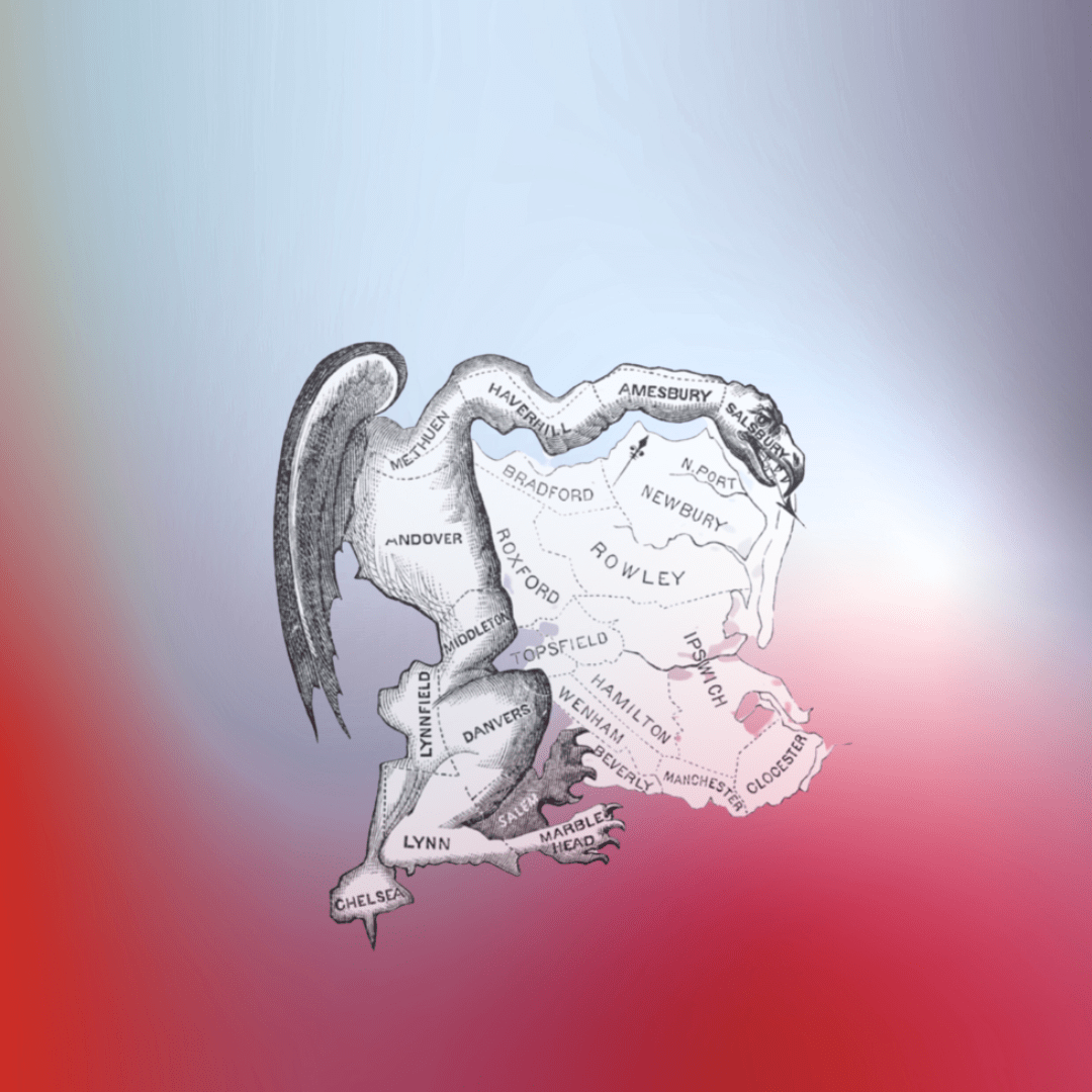
In 1812 the state adopted new constitutionally-mandated electoral district boundaries. The Republican-controlled legislature had created district boundaries designed to enhance their party’s control over state and national offices, leading to some oddly shaped legislative districts. Although Gerry was unhappy about the highly partisan districting (according to his son-in-law, he thought it “highly disagreeable”), he signed the legislation. The shape of one of the state senate districts in Essex County was compared to a salamander by a local Federalist newspaper in a political cartoon, calling it a “Gerry-mander.” Ever since, the creation of such districts has been called gerrymandering. [source]

The word “gerrymander” (originally written “Gerry-mander”) was used for the first time in the Boston Gazette newspaper on March 26, 1812.[78] Appearing with the term, and helping spread and sustain its popularity, was this political cartoon, which depicts a state senate district in Essex County as a strange salamander-shaped animal with claws, wings and a dragon-type head, satirizing the district’s odd shape.
Redistricting on the grandest scale…

Dr. Andrew Shears is a geographer by both vocation and avocation. Fascinated by American history, and by what might have been, he created the map above…
I discovered a list that really intrigued me like none other: the List of U.S. State Partition Proposals. For a geographer/cartographer who’s a U.S.-specialist and who’s interested in alternate history, this was Kryptonite for my productivity. From this list, I stumbled onto listings for U.S. Territories that Failed to Become States and the listing for the hypothetical 51st State. I even came across a nice little book called Lost States, a humorous account from Michael Trinklein that briefly explores a number of random states that never quite happened.
After reading all of these things, and all of the linked pages connected — that’s where Wikipedia really sucks you in — I, of course, allowed my own mind to wander and I came up with the beginnings of a historical geography narrative for the United States of my own, drawing on each of these sources. How could I spell this out? Well, I’m no novelist, because I just really don’t have the imagination or skills necessary to put together a story in that format. However, I can make maps here and there, and I firmly believe that maps can do a pretty good job telling a story.
What did I end up with? My own alternate history U.S. map of 124 states…
As one watches the U.S. government congeal into an unappetizing mess– as representatives, “serving” districts and states shaped though decades and decades of gerrymandering, vote narrow interests in search of advantage in elections-to-come– we might ponder Dr. Shear’s reminder of how differently it might all have looked… if only for the reminder that it didn’t have to be– nor does it have in the future to be– this way.
###
As we wonder what in the world became of Mr. Smith, we might recall that it was on this date in 1861 that President James Buchanan signed into law the Congressional Act creating the “organized incorporated Territory of Colorado.” The land had come to the U.S. in 1848 as part of the spoils of the Mexican-American War. Then populated virtually exclusively by Native Americans, white settlers flooded in with the Pike’s Peak Gold Rush in 1858. Pressure from those new arrivals, along with a different kind of pressure felt by Washington as Southern states were seceding in the run-up to the Civil War (this was the period immediately before Lincoln’s inauguration), spurred the action– which expanded the Union and gave it access to the gold and other minerals in the Southern Rockies.

You must be logged in to post a comment.