Posts Tagged ‘ballooning’
“Those who first invented and then named the constellations were storytellers. What it changed was the way people read the night sky.”*…
Scheduling Note: (Roughly) Daily will be off tomorrow, but should return on Saturday…
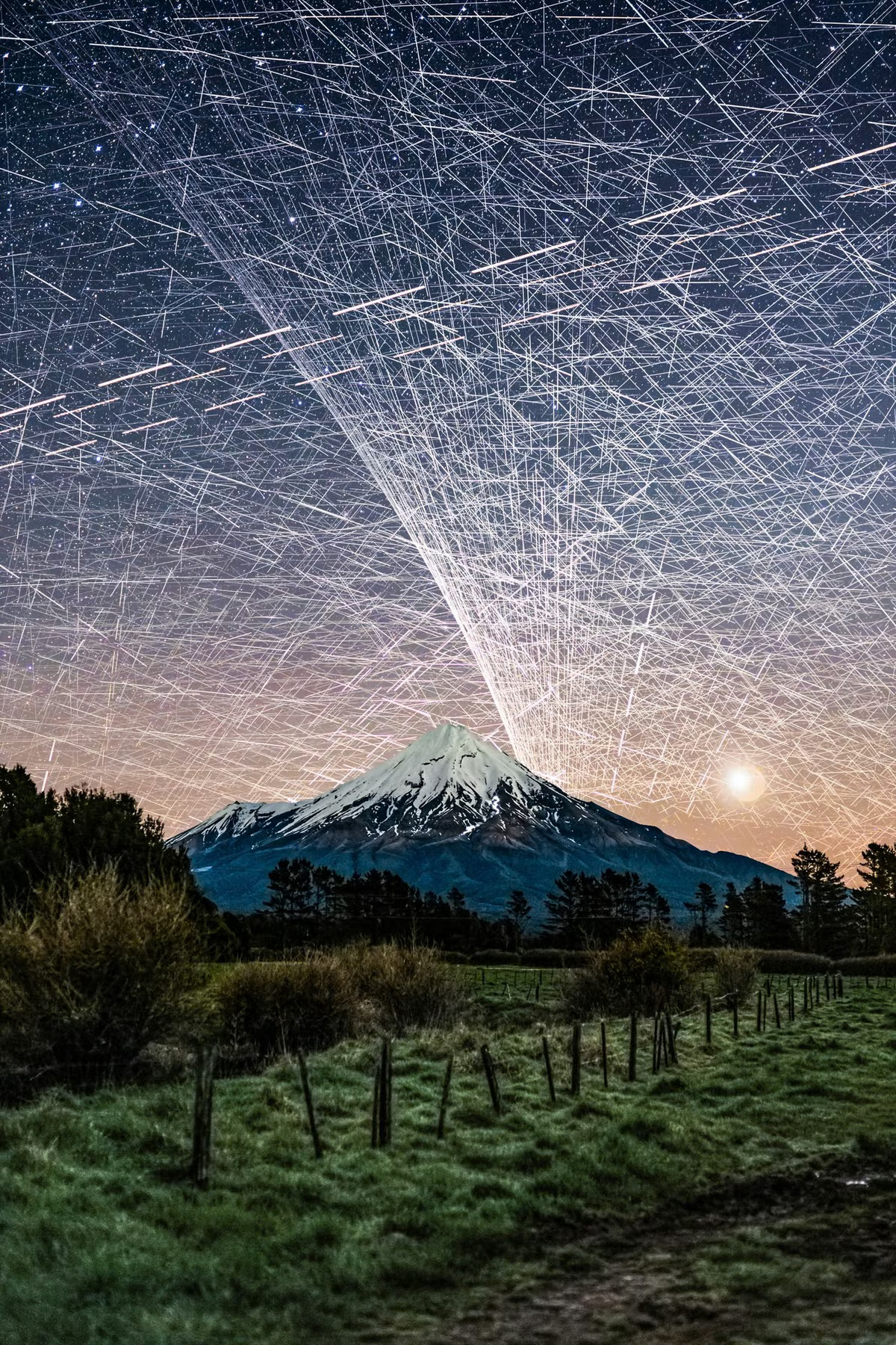
Astronomers, photographers, and star gazers in general have been living with (that’s to say, looking for out-of-the-way locations in order to avoid) light pollution for over a century. But of late, they’ve been grappling with a newer challenge: bright satellites that stand, like grafitti, between observers — no matter how remote — and the treasures of the night sky.
Photographer Brendan Larsen created a striking demonstration, as Kottke.org reports..
To create this composite image [and as above], photographer Brendan Larsen captured almost 600 photographs over a two-hour period and then manually stitched them together.
This is the most time-consuming photo edit I’ve EVER done!
I left my camera photographing the night sky over Mt Taranaki [see here] for nearly TWO HOURS, capturing 578 photographs.
The result? An estimated 14,450 satellite trail appearances, representing approximately 1,400 individual satellites! 😱
I manually masked in EVERY SINGLE TRAIL from the original photographs — approximately 45 HOURS of editing to create this one image!
The Guardian has more on how he created the image (which, despite many online commenters’ beliefs, is not AI):
Larsen, 51, says he set his camera up to take an unlimited number of eight-second-long shots, with a two-second gap in between each photo. “I left her running for two hours and captured 578 photos … That was the easy part.”
The hard part came next. Larsen spent about 45 hours layering the individual photos – each of which contained about 25 satellites – over one another, using Adobe Photoshop. Much of the time was spent painstakingly erasing stars, to reveal the satellites.
“I could start to see the pattern emerging and realised: ‘Wow, this looks really awesome.’ I knew if I carried on it would look even better and more impressive in terms of satellite numbers.” [source article]
Fellow photographer Vincent Laforet called Larsen’s image “an important photograph”:
I was initially startled. Then confused. Then fascinated all in quick succession.
And then I felt a deep sense of betrayal once I realized that what I was tracking with my eyes were a series of small satellites. And btw: that they likely had ruined my long exposure that I was capturing at the time.
I remember asking in the moment:
Who gave anyone permission do this?
What’s between us and the stars: “Stunning Image of Our Satellite-Choked Night Skies,” from @kottke.org.
###
As we search the skies, we might send far-sighted birthday greetings to Audouin Dollfus; he was born on this date in 1924. An astronomer and aeronaut, he was the successor to Bernard Lyot as the principal French authority on the solar system; Dollfus discovered Janus, a moon of Saturn.
While Dollfus made use of terrestrial telescopes, he was creative in finding a way past the challenges of light pollution and closer to the objects of his study. With his father (the aeronautical pioneer Charles Dollfus), he holds several world records in ballooning, including the first stratospheric flight in France. He was the first to carry out astronomical observations from a stratospheric balloon, in particular to study Mars in a detailed way.
The asteroid 2451 Dollfus is named in his honor, and one of the largest craters on Mars was also named for him.


“Like guns and crosses, maps can be good or bad, depending on who’s holding them, who they’re aimed at, how they’re used, and why”*…

“A New and Accurat [sic] Map of the World,” John Speed 1626. For background, see here
We expect maps to tell us the truth. They seem trustworthy, after all: when you need to figure out how to get from Copley Square to Fenway Park, or if you’re interested in comparing the income levels of Boston’s neighborhoods, the first reference material you’re likely to seek out is a map.
But maps, truth, and belief have a complicated relationship with one another. Every map is a representation of reality, and every representation, no matter how accurate and honest, involves simplification, symbolization, and selective attention. Even when a map isn’t actively trying to deceive its readers, it still must reduce the complexity of the real world, emphasizing some features and hiding others. Compressing the round globe onto a flat sheet of paper, and converting places, people, and statistics into symbols, lines, and colors is a process inherently fraught with distortion.
Meanwhile, what we understand to be true is based on what we have seen in maps. For example, how do you know that New Zealand is an island off the coast of Australia if you’ve never been on a ship in the Tasman Sea or flown up in space to see it yourself? That fact about the world is one you can believe because you’ve seen it reproduced over and over again in maps produced by people and institutions that you trust…
Because they seem to show the world how it “really is,” maps produce a powerful sense of trust and belief. But maps and data visualizations can never communicate a truth without any perspective at all. They are social objects whose meaning and power are produced by written and symbolic language and whose authority is determined by the institutions and contexts in which they circulate. From the Boston Public Library’s Norman B. Leventhal Map & Education Center, a remarkable online exhibit that explores the many ways in which maps and data can mislead: BENDING LINES: Maps and Data from Distortion to Deception. (Lots of fascinating information and LOTS of glorious maps!)
See also: “How to Detect the Distortions of Maps.”
And lest we underestimate the innate challenges facing cartographers, “The U.S. Is Getting Shorter, as Mapmakers Race to Keep Up.”
* Mark Monmonier, How to Lie with Maps
###
As we aspire to accuracy, we might recall that it was on this date in 1784 that Élisabeth Thible became the first women to ascend in an untethered balloon (eight months after the first manned balloon flight). When the balloon left the ground Thible, dressed as the Roman goddess Minerva, and her pilot, Monsieur Fleurant sang two duets from Monsigny’s La Belle Arsène, a celebrated opera of the time. The flight lasted 45 minutes, covered four kilometers, and achieved an estimated height of 1,500 meters. Their audience included King Gustav III of Sweden, in whose honor the balloon was named.

Élisabeth Thible on a later flight
“Why haven’t we seen a photograph of the whole Earth yet?”*…

Detail from the “Balloon-Prospect” image, featured in Thomas Baldwin’s Airopaidia (1786) [source]
Although it is often dismissed as a comedy moment, an amusing episode in the history of flight, ballooning had a profound effect on the epistemological model of being in the world and viewing landscape. That balloons are innately comic is undeniable, and their physical attributes were a gift to satirists of the late eighteenth century, who riffed delightedly on the graphic and semantic associations of this new and somewhat unlikely technology. Furthermore, in the first few decades of ballooning, its utility was unclear. Although flight had been achieved, the power to navigate had not, so balloons could not be used as aerial transport. Once airborne, balloonists were dependent on the mysteries of the upper air and its currents to carry them along. In this captive state, aeronauts set about conducting experiments with a full array of scientific instruments, their own senses and perception being among these. Tasting ginger to see if it was as spicy, or undertaking a complex mathematical equation to test mental acuity at altitude, went alongside checking height and air pressure.
In some cases, science funding had got them up there in the first place. The first successful manned balloon flights were conducted in France with state support. The ascents themselves became known as “experiments”, and were concerned with an exploration of the upper air. In Britain, the Royal Society withheld support from such endeavours, so the first British ascents were underwritten, in the words of one early balloonist, by “a tax on the curiosity of the public”. This affected the cultural profile of ballooning in England: it was always more of a spectacle than a science. In 1785 Tiberius Cavallo, a member of the Royal Society and author of the first English history of ballooning, concluded that:
…many, if not the greatest number of the aerial voyages, though said to be purposely made for the improvement of science, were performed by persons absolutely incapable of accomplishing this purpose; and who, in reality, had either pecuniary profit alone in view, or were stimulated to go up with a balloon, for the sake of the prospect, and the vanity of adding their names to the list of aerial adventurers….
The late-18th Century version of Stewart’s impulse: “‘For the Sake of the Prospect’: Experiencing the World from Above in the Late 18th Century.
* Stewart Brand, as part of his 1966 campaign to have NASA release the then-rumored satellite image of the entire Earth as seen from space
###
As we jettison the sandbags, we might send high-flying birthday greetings to Amelia Earhart; she was born on this date in 1897. An aviation pioneer and author, she was the first female to fly solo across the Atlantic (a distinction for which she received the U.S. Distinguished Flying Cross).
Earhart set many other records, wrote best-selling books about her flying experiences and was instrumental in the formation of The Ninety-Nines, an organization for female pilots. She joined the faculty of the Purdue University aviation department in 1935 as a visiting faculty member to counsel women on careers and help inspire others with her love for aviation, and was a member of the National Woman’s Party, and an early supporter of the Equal Rights Amendment.
During an attempt to make a circumnavigational flight of the globe in 1937 in a Purdue-funded Lockheed Model 10 Electra, Earhart disappeared over the central Pacific Ocean. Fascination with her life, career, and disappearance continues to this day.

You must be logged in to post a comment.