Posts Tagged ‘natural disasters’
“If lightning is the anger of the gods, then the gods are concerned mostly about trees”*…

Mostly, but not entirely. Chloe Aridjis on survivors of lightning strikes…
There are three types of lightning: cloud to cloud, or intercloud, which leaps across gaps of clear air; intracloud, which doesn’t leave the cloud at all; and cloud to ground, the most threatening: a stream, or rather a meeting of two streams, of ionised particles, each following its own determined course, one towards the heavens, the other towards earth, and where they meet the air crackles with heat, creating a sky of forking paths.
To the attendees of the International Lightning Strike Survivor Conference, who have all had encounters with the third kind, the oft-mentioned statistic (nine out of ten survive) offers little consolation. Many of them, given the consequences, would prefer to have been struck dead. Survival provides small solace when your entire existence has been electrically altered.
Just as lightning isn’t a single event but rather a sequence of strokes, so the memory of a lightning strike returns in fierce, dramatic bolts rather than as one clear picture.
…
Distinguished ornithologist ALEX COSTA from Tampa, Florida, the lightning state (three times more strikes than any other in the US), was observing a rare migratory bird when struck, and when he returned to his senses the bird had vanished along with his shoes, binoculars and long-term memory. Indoor landscape painting (he rarely leaves home) has replaced ornithology and, with his good hand, he now paints imaginary woods and meadows. He doesn’t sleep much at night but reads and takes long naps in his armchair by the window….
What is it like to be touched by a lightning bolt? More current-charged recollections: “Notes on the International Lightning Strike Survivor Conference,” at @thedialmag.
* Lao Tzu
###
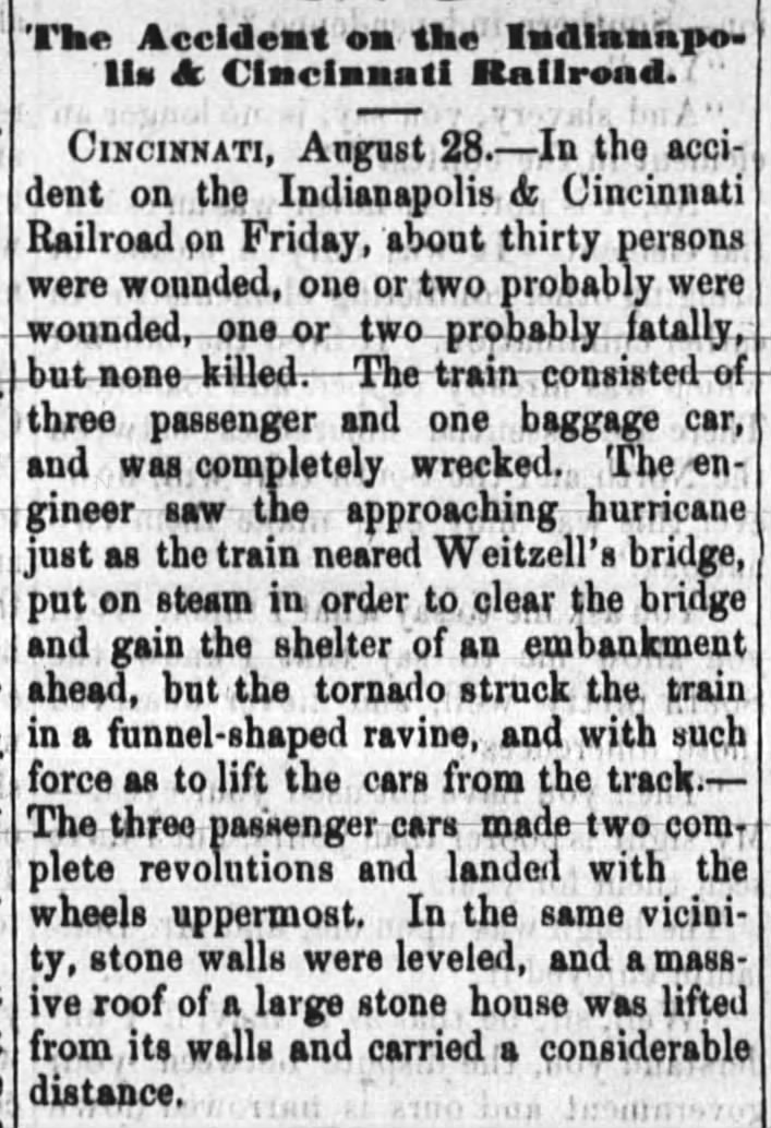
As we take cover, we might remember that it was on this date in 1864 that a train running from Cincinnati to Chicago was derailed by a tornado in Dearborn County, Indiana (about 75 miles southeast of Indianapolis). Three passenger cars were lifted from the tracks and dropped in a ravine, injuring 30 people.
Out of harm’s way?…

The online real-estate service Trulia has crunched federal-disaster data to create a series of local maps and a collection of national maps showing the worst cities to live in for weatherphobes and quake-haters – stay out of California metropolises if you fear having your home burnt down, for instance, and Oklahoma City is a terrible place to hunker if you don’t want EF-4 twisters knocking at your door. The Trulia team warns:
Most metros were high risk for at least one of the five natural disasters [hurricanes, tornadoes, floods, forest fires and earthquakes], even though no metro area is high risk for everything. Earthquakes and wildfires tend to go hand-in-hand, with California and other parts of the West at high risk for both. Hurricanes and flooding also tend to strike the same places, particularly in Florida and along the Gulf Coast. Tornadoes affect much of the south-central U.S. What parts of the country are left? Not the Northeast coastal cities, which – as we all know after Hurricane Sandy – face hurricane and flood risk. Instead, the metros at medium-to-low risk for all five disasters span Ohio (Cleveland, Akron, and Dayton), upstate New York (Syracuse and Buffalo), and other parts of the Northeast and Midwest, away from the coasts…
Where should one head to avoid the next great storm? Here are the top 10 large housing markets in America that are most removed from “nature’s wrath,” according to the company’s risk assessment (the prices refer to the average home-asking price per square foot):
- Syracuse, New York* ($89)
- Cleveland ($80)
- Akron, Ohio ($81)
- Buffalo ($93)
- Bethesda-Rockville-Frederick, Maryland ($174)
- Dayton, Ohio ($72)
- Allentown, Pennsylvania-New Jersey ($109)
- Chicago ($113)
- Denver ($129)
- Warren-Troy-Farmington Hills, Michigan ($94)
* Syracuse: Trulia says the “data on flood risk, which comes from the Federal Emergency Management Agency [FEMA], is incomplete for Syracuse and for several other metros not on the ten lower-risk list.”
Read the whole story at “These U.S. Cities Are the Safest Refuges From Natural Disasters“; and explore the Trulia maps here.
###
As we dream of Oz, we might recall that it was on this date in 1834 that Mt. Vesuvius erupted. Again.
Vesuvius famously erupted in 79 CE, destroying Pompeii and Herculaneum; but the volcano had erupted many times before, and has again, many times since.
The last major eruption was in March 1944. It destroyed the villages of San Sebastiano al Vesuvio, Massa di Somma, Ottaviano, and part of San Giorgio a Cremano. At the time of the eruption, the United States Army Air Forces 340th Bombardment Group was based at Pompeii Airfield near Terzigno, Italy, just a few kilometers from the eastern base of the mountain. Tephra (rock fragments ejected by the eruption) and hot ash damaged the fuselages, the engines, the Plexiglas windshields, and the gun turrets of the 340th’s B-25 Mitchell bombers; estimates were that 78 to 88 aircraft were completely destroyed.

Vesuvius from Portici by Joseph Wright of Derby
You must be logged in to post a comment.